Jetty

Jetty Built

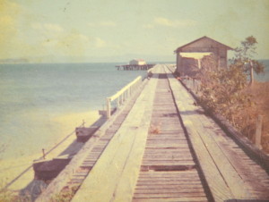
The jetty at Portland Roads was built in about 1938/39 to service the gold mining activities at Batavia Goldfield (later called Wenlock) and the Iron Range area. It was 810 feet long to reach the deep water. A tramline ran out to the wharf (60 ft x 30 ft) at the end of the jetty. There was a shed located on the wharf.

“the jetty is now complete” announced The Cairns Post, on Friday 25 November 1938. It seems that this was according to a report of the Queensland Department of Harbours and Marine for the year ended June 30, 1938, so presumably the jetty was actually completed before the end of the financial year 1938.

On 27 September 1938 it was reported that the jetty was used for the first time by the steamer Wandana.

In August 1937, the Mines Department requested a jetty be designed and built to service the Batavia (later called the Wenlock) Goldfields and the Iron Range area.

Jetty plans were submitted to the Mines Department on October 29, 1937 with an estimated costing of £5778. The Minister approved the project with a maximum budget of £6000; tenders were called for on November 15th and accepted on December 15th.

It was reported on 24 Jan 1938 that “Work is proceeding on the construction of a jetty at Portland Roads, the Peninsular port for the Bartavia and Iron Range goldfields”.

The dimensions of the jetty were as follows, according to the Cairns Post on Fri 25th November 1938: “The jetty is 813 feet 9 inches over all length, with a T-head 60ft by 30ft, and a stem 10ft wide, with a 20ft by 15ft shed on the T-head, and a 3ft 6in tramway along the jetty. There is 15ft 6in at low water at the jetty berth.
Regulations for the control of the jetty have been gazetted.”
(CITE: Article identifier: http://nla.gov.au/nla.news-article42152478)
Jetty
Jetty


Aboriginal Protection Restriction of the Sale of Opium Act 1897

“The Queensland Parliament passed the first Act exclusively devoted to regulating every element of Aboriginal lives, the Aboriginal Protection and Restriction of the Sale of Opium Act in 1897.” Aboriginal Protection Restriction of the Sale of Opium Act 1897

The government of the day used this act to move Lockhart people from “Old Site” to Lockhart in 1969.
Lucy Hobson remembers:
“It was 1969 that we moved over, as I remember I was the last one to move from Lockhart mission.
My husband was cooking up at the store, so we had to send all the people, they were all old people left there for the next trip to come. Some, just didn’t want to move. So we had to stay there ’til, you know, the food line because of the store.”

naming of portland roads

Cook’s journal – Weymouth Bay Naming

Cook’s log states that he named Cape Weymouth and Weymouth Bay presumably after Viscount Weymouth but did not mention Portland Roads.

“On the Mainland within us was a pretty high promontory, which I called Cape Weymouth (Latitude 12 degrees 42 minutes South, Longitude 217 degrees 15 minutes); and on the North-West side of this Cape is a Bay, which I called Weymouth Bay.” (Cook’s Journal August 16th 1770)

Weymouth is next to Portland in England; Viscount Weymouth and Duchess of Portland were of the same family

The natural Portland anchorage is known as the Portland Roads.

naming of portland roads
naming of portland roads (opens as a pdf)

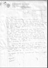
Geoff Pope supplied a document from the British Hydrographic Department that states that the first mention of Portland Roads is in the sailing directions of Lieut Hemmings 1896 from Cape Weymouth to Torres Strait.

Cook named the Isle of Portland in NZ after the Isle of Portland in UK because it looked similar

The Duchess of Portland was a great collector of items that Joseph Banks collected on his journeys.